GIS & Drone Services

Our Services

GIS & DRONE SERVICES

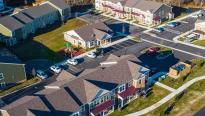
Using our Smart Site Plan™ technology, RAUCH has developed the most advanced asset management tool to enhance projects by improving informed decision-making and increasing data accessibility throughout the entire project life cycle. We make our data available in a powerful interactive web app accessible anywhere.

Aerial Survey & Mapping

Our FAA Part 107 certified pilots operate professional-grade drone platforms to capture data faster and more affordably than traditional methods. What used to take a survey crew weeks can now be mapped in days, with higher resolution and broader coverage.

  • Up-to-date aerial imagery
  • Detailed topography mapping
  • Drainage area identification
  • Construction progress tracking
  • Volume calculations
  • Thermal inspection using FLIR

GIS & Spatial Analysis

We build geographic information systems that turn raw data into actionable intelligence. Whether it's a county-wide parcel database or a utility asset management system, our GIS analysts create tools that help organizations make smarter decisions about their land and infrastructure.

  • Real-time GIS model for water, wastewater & stormwater utilities
  • Fire hydrant, cleanout, and water meter tracking
  • Emergency preparedness planning
  • Utility system maintenance planning
  • Construction upgrade coordination
  • Subdivision planning support

3D Building Reconstruction

Combining aerial survey, GIS data, and 3D modeling, we create digital representations of real-world environments. These digital twins support planning, design review, and stakeholder communication in ways that flat drawings simply can't match.

Our Work in Action

From the Field

Aerial drone photograph of a completed townhome and apartment development with parking lots, sidewalks, and a road intersection surrounded by autumn trees
Aerial drone photograph of a residential golf course community showing a large clubhouse, swimming pool, pedestrian bridge over a stormwater pond, and surrounding homes
Aerial drone photograph of a residential subdivision street lined with single-family homes in autumn, bordered by a golf course with sand traps and waterfront
Aerial drone photograph of an active residential construction site adjacent to a golf course, showing graded lots, construction equipment, and a waterway
Aerial drone photograph of a mixed residential and golf course community under construction, featuring a stormwater pond with fountain and a cul-de-sac
Straight-down aerial drone photograph of a residential cul-de-sac with driveways, parked vehicles, sidewalks, and landscaped yards in an autumn neighborhood
Wide aerial drone photograph of a large mixed-use golf course community showing a canal with a vehicle bridge, clustered residential homes, and retention ponds
Silhouette of a quadcopter drone being launched by an operator against a vivid orange and blue sunset sky
Aerial drone photograph of a commercial strip mall with storefronts, a large paved parking lot, and surrounding industrial buildings
Silhouette of a compact folding drone in flight against a warm golden-orange sunset sky with the sun visible near the horizon
GIS data layer displayed in Google Earth Pro showing color-coded sewer pipe network lines with manhole data popups overlaid on aerial imagery
GIS utility mapping of a rural sewer network in Google Earth, showing branching lateral and main sewer lines color-coded over fields and tree cover
RAUCH aerial GIS parcel map showing farmland divided into labeled acreage parcels with property boundaries drawn over an aerial photograph
Wide aerial drone photograph of a large residential subdivision under construction showing graded lots, new road infrastructure, and a curving waterway
Straight-down aerial drone photograph of graded earthwork lots at an active construction site, showing tiered cut-and-fill slopes and heavy equipment tracks
Aerial drone photograph of a harvested farm field with the word RAUCH carved in large block letters into the crop stubble
Aerial photograph of a small marina on a tidal waterway showing multiple boat slips with docked sailboats and powerboats and a waterfront building complex

Get in touch

Have a gis & drone services project in mind?

Every project starts the same way: with a conversation about what matters most to you. Let's sit down and talk about yours.

Other services